-
Travle: Geographical knowledge

Travle is an interactive game where you get two countries on a map or two provinces. Your job is to get from one to the other. You do this by typing the name of a country or province and adding it to the map, on which your route becomes visible. …
Translated by
 Interactive exerciseTeacher, ICT co-ordinator
 -
Seterra Geography: Blind map exercises

With the exercises on this website you can practice continents, countries, rivers, capitals, rivers on a blind map.
After selecting a card, you must click on what is requested by time.
Translated by
Interactive exercise (3)Teacher -
Editor.Pho.to: Edit your photos online

On this website you can easily edit photos: crop, rotate, adjust colors, ....
You can add effects, stickers, frames, text or textures to your photo.
Translated by
App or softwareTeacher, Other -
Go goals: SDG board game

The game is intended to inform children and young people around the world about the sustainable development goals in a simple and child-friendly way.
Translated by
Downloadable resourceTeacher -
Digital journey to the European Parliament: 360° tour

Take a virtual tour of Parliament in Brussels and Strasbourg, meet Members of the European Parliament and gain a better insight into the work at the heart of European democracy.
Dive into the VR world and immerse yourself in the role of a …Translated by
App or softwareTeacher, Other -
European Union: Map
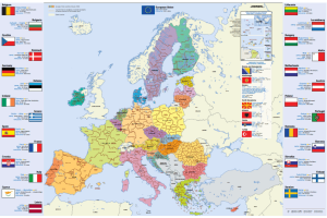
Map of the European Union, Dutch (or in another European language), in A4 format.
You will find this information per country: flag, capital, area, population, currency.
You can download or order this map.
Translated by
Downloadable resource
-
Ellen MacArthur Foundation: Circular Economy Teaching Material

The Ellen MacArthur Foundation works for a fully circular economy. It was founded in 2009 and is a reference for the circular economy. You will find a wealth of information: infographics, reports, but also a specific section with educational …
Translated by
Website
-
Learn to recognize and name the colors: Magic with colors

Miss Taise shows you a simple, but very fun way to learn to recognize and name the colors. Bring out the colors.
Translated by
Video (6)Teacher, ICT co-ordinator, … -
Our planet, our future: Informative site with worksheets

Our planet, our future is an online platform that can help young people to better understand the causes and consequences of climate change, while offering solutions on how to make our society climate-friendly. The platform combines science, …
Translated by
Downloadable resource (3)Organisation, company, NPO -
BABADADA: Picture dictionary in different languages

Discover more than 1000 prints with descriptions in two languages.
The images are sorted by theme (body, school, colors, house, ...) and you can choose from 90 languages. Some examples:- Dutch - Arabic ,
- Polish - English ,
- French - Hebrew , …
Translated by
Website (67)Teacher, Learning mentor -
Seterra Geography

With this app you can practice continents, countries, rivers, capitals, rivers on a blind map.
After selecting a card, you must click on what is requested by time.
Translated by
App or software (5)Teacher -
Toporopa: Topography of Europe

Toporopa is intended for anyone who wants to get to know the topography of Europe better. Various things can be practiced here: Euro countries, rivers, mountain ranges, monarchies, seas, metropolises, islands, capitals, volcanoes, flags, ports, …
Translated by
Website (19)Teacher
Yummmm… cookies!
We don't like being tracked either. That's why we're concerned about your privacy.
Necessary cookies: for the proper operation of the website.
Functional cookies: for your convenience. recommended
Social media cookies: to view embedded media such as videos from YouTube, Facebook … recommended
Statistical cookies: for anonymous data collection to enhance user experience.