-
Contours of EU Member States: Combining exercise

Recognize and combine the contours of the European countries. This learning resource is based on Outlines of the EU Member States: Game of Europe Direct Province of Antwerp
Translated by
 Interactive exerciseTeacher
 -
Atlas skills

With this interactive exercise, your students will learn to know and use the different parts of their atlas:
- register,
- legend,
- table of contents.
Source: Atlas skills by Anke Vandermeersch
Translated by
Interactive exerciseTeacher -
European Union: Map
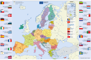
Map of the European Union, Dutch (or in another European language), in A4 format.
You will find this information per country: flag, capital, area, population, currency.
You can download or order this map.
Translated by
Downloadable resource
-
May plastic-free: Inspiration list

Soon Mei Plasticvrij will start again, an awareness campaign about the impact of our plastic consumption on the environment.
There are a lot of physical and digital educational materials to get started during this month on the use of plastic, waste, …
Translated by
Downloadable resource (4)
-
Horizontally and vertically

Look carefully at the photo. Find the red lines and indicate whether the line is vertical or horizontal.
Translated by
Interactive exercise (3)Teacher, ICT co-ordinator
Yummmm… cookies!
We don't like being tracked either. That's why we're concerned about your privacy.
Necessary cookies: for the proper operation of the website.
Functional cookies: for your convenience. recommended
Social media cookies: to view embedded media such as videos from YouTube, Facebook … recommended
Statistical cookies: for anonymous data collection to enhance user experience.