-
ArcGIS: Exercises

You will find various ArcGIS class tasks or homework tasks here. These are fill-in files in Word:
- familiarize yourself with ArcGIS including creating a public account;
- check the characteristics of the Mercator projection experimentally; …
Translated by
 Downloadable resourceTeacher
 -
European Union: Map
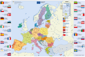
Map of the European Union, Dutch (or in another European language), in A4 format.
You will find this information per country: flag, capital, area, population, currency.
You can download or order this map.
Translated by
Downloadable resource
-
Morphology of the seabed: Google Earth

An ICT task on the morphology of the seabed.
The students make a relief cross-section with Google Earth Pro.Translated by
Downloadable resourceTeacher -
Working with Geopunt (GIS viewer)

An exercise to get to know the different functions of Geopunt, adapted to our school environment, but can be adapted (word document).
The curriculum goal "The students use GIS viewers to investigate thematic layers of a place and their …
Translated by
Downloadable resource (15)Teacher -
A bird's eye view: Lesson idea

The students start from aerial photographs and convert their observations into a floor plan or 3D representation. Scale, bird's eye view ... are discussed.
As an extra: how do you make a blueprint?
Translated by
Downloadable resource (6)
-
Historical map material: Lesson idea

Lesson Idea Historical map material on the theme Discover immovable heritage in your school neighbourhood.
With historical maps, the students get to work in environmental education. By comparing them with contemporary maps, they gain insight into the …
Translated by
Downloadable resource (4)
-
Topo Europe: Lesson sheet
This learning tool will help you get started with the Topo Europa: Game about topography app
You will find the following items in it:
- target audience;
- Discipline;
- price;
- goals;
- Description;
- lesson ideas;
- tips;
- screenshots with explanations.
Translated by
Downloadable resource (5)Teacher
Yummmm… cookies!
We don't like being tracked either. That's why we're concerned about your privacy.
Necessary cookies: for the proper operation of the website.
Functional cookies: for your convenience. recommended
Social media cookies: to view embedded media such as videos from YouTube, Facebook … recommended
Statistical cookies: for anonymous data collection to enhance user experience.