-
Travle: Geographical knowledge

Travle is an interactive game where you get two countries on a map or two provinces. Your job is to get from one to the other. You do this by typing the name of a country or province and adding it to the map, on which your route becomes visible. …
Translated by
 Interactive exerciseTeacher, ICT co-ordinator
 -
Seterra Geography: Blind map exercises

With the exercises on this website you can practice continents, countries, rivers, capitals, rivers on a blind map.
After selecting a card, you must click on what is requested by time.
Translated by
Interactive exercise (3)Teacher -
weADAPT: Climate adaptation

weADAPT is a global cooperation platform on climate change. Discover the latest knowledge, share your own work and connect with others dealing with similar challenges.
Translated by
WebsiteTeacher -
Go goals: SDG board game

The game is intended to inform children and young people around the world about the sustainable development goals in a simple and child-friendly way.
Translated by
Downloadable resourceTeacher -
Open Roberta: Programming Tool

Open Roberta is an online application that allows users to program robots and microcontrollers. The script can be built with blocks or with code. You can also view the configuration of your device and perform a digital simulation.
Translated by
App or softwareTeacher -
All Children All Right(s)!: Audio Stories

Mobile School developed the toolkit All Children, All Right-s! to engage youth workers, teachers... to promote children's rights. The toolkit consists of four components: short online trainings, educational posters, games and activities, and …
Translated by
Audio
-
FluidDraw: Educational License

Teachers and students can request a free license for FluidDraw via a contact form. This software has been developed to draw pneumatic and electrical circuit diagrams.
Translated by
App or software
-
European Union: Map
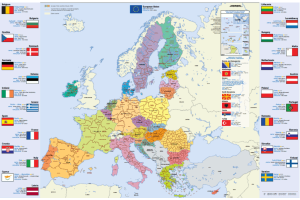
Map of the European Union, Dutch (or in another European language), in A4 format.
You will find this information per country: flag, capital, area, population, currency.
You can download or order this map.
Translated by
Downloadable resource
-
IRCEL: Interregional Cell for Environmental Measurements

This website provides your students with accurate air quality data in Belgium. For example, they can look up measurements of nitrogen, sulfur and carbon oxides, ozone, particulate matter and some organic compounds per municipality.
Translated by
WebsiteTeacher -
Virtual Reality in the classroom: Applications and examples

Extensive list of links to various virtual reality applications for technical and general subjects. You will receive examples of VR for the following courses:
- car,
- wood and construction,
- electricity and central heating,
- VOICE,
- math,
- Sciences, …
Translated by
Downloadable resource (9)Teacher -
Our planet, our future: Informative site with worksheets

Our planet, our future is an online platform that can help young people to better understand the causes and consequences of climate change, while offering solutions on how to make our society climate-friendly. The platform combines science, …
Translated by
Downloadable resource (3)Organisation, company, NPO -
Together on the road: The path of the patient (film Damien Foundation)

Damien Foundation showed children in Belgium how difficult it can be for some to recover from a disease. There are children who live too far from the doctor and others who, for example, are given the wrong medicines. Walk the path of the patient …
Translated by
Video
Yummmm… cookies!
We don't like being tracked either. That's why we're concerned about your privacy.
Necessary cookies: for the proper operation of the website.
Functional cookies: for your convenience. recommended
Social media cookies: to view embedded media such as videos from YouTube, Facebook … recommended
Statistical cookies: for anonymous data collection to enhance user experience.